2D - mapping
See how 2D mapping is changing the way industries plan, estimate, & measure in the workplace and how it can start saving your company in lost time and money right away.
This is ACTIONABLE RESULTS DELIVERED!!

what is 2d orthomosaic mapping?
Orthomosaic mapping using unmanned aerial vehicles (UAVs) is a process of creating a high-resolution map of a specific area by stitching together multiple overlapping images taken from a UAV. The process involves using photogrammetric techniques to accurately align and blend the images together, while also removing distortion and ensuring that the final map has a consistent scale and accurate measurements. The resulting orthomosaic map can be used for a variety of applications such as maintaining facilities or campuses, monitoring construction progress, and managing natural resources.
Construction site
2D Map of Construction Site
why use 2D mapping for your organization?
Our 2D Mapping service provides our clients the ability to see their worksite, project, or event from the air and in High Definition detail. These maps are interactive and allow users to conduct a wide variety of tasks from the comfort of their desktop. You might ask; why not just use the free online map applications that we are already familiar with? The answer is simple, if you depend on your information being accurate and up to date, then free online satellite map applications will fail you every time. This is largely because the satellites that are responsible for taking the imagery that make up these maps, only come around every few months. This results in out-of-date satellite imagery that cannot be relied on for projects that require more detail, and accuracy.
Google Maps
free online maps vs. our 2D maps
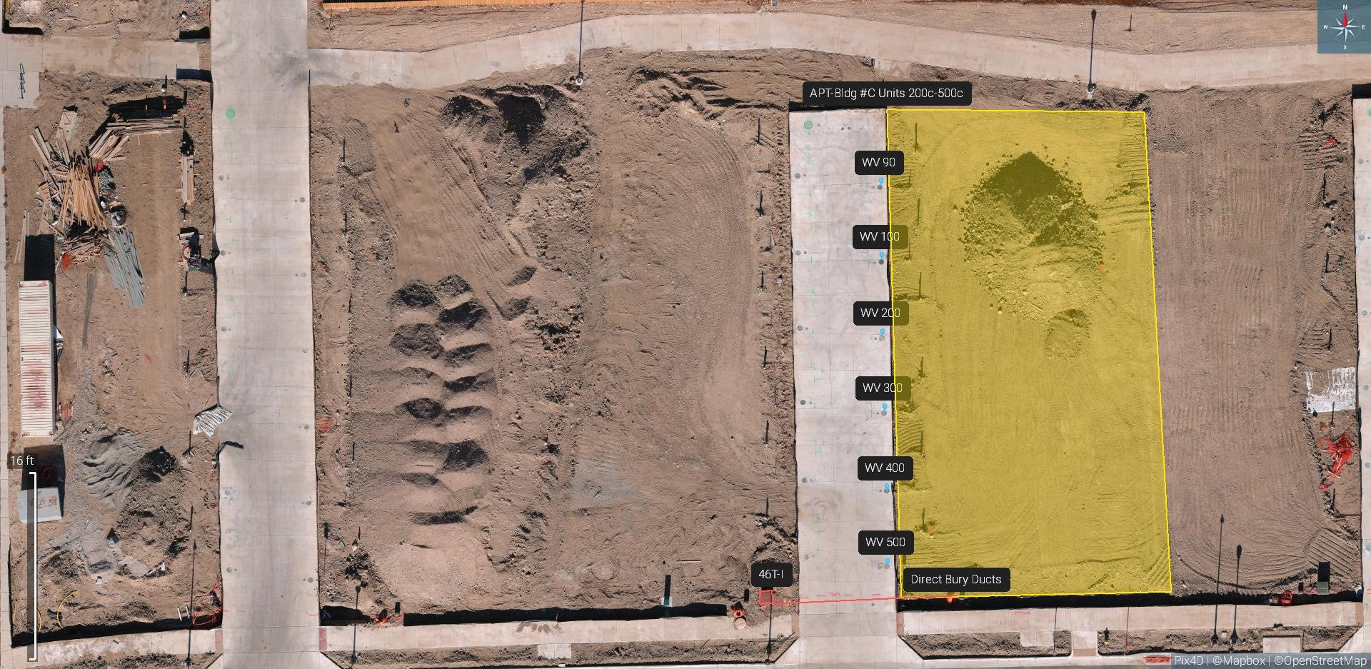
The Google map image of the worksite (above) was taken on the same day we flew our mapping mission of the worksite (below). As you can see, the Google map is outdated and does not show the current status of the project and worksite. Our map below shows, in detail, all concrete, sewer lines, electrical connection points, etc. that have been installed by the contractor up to this point in the project’s lifecycle.
What makes our 2D mapping service even more powerful is the ability to zoom in and out, take linear and area measurements, and mark points of interest remotely and with accuracy. Once all measurements, markers, and descriptions have been recorded, you can then export a pdf. report complete with your company logo. This pdf. report breaks down each measurement, annotation, and description you made previously, into an easy to ready report that can quickly be shared with other stakeholders.
Our 2D map
Watch our 2D Mapping Demo Reel to see it in ACTION!
how to use 2D maps for your industry?
Construction
Routinely create 2D maps of your construction site to monitor project status, identify new hazards, track materials inventory, communicate with stakeholders, create reports, and more.
Facility Maintenance
Building managers, site managers, and contracting estimators can all benefit from using 2D mapping to track construction projects on campus, monitor grounds health, create in house estimates with ease, communicate with contractors, share maps and annotations, and more….
Event Planners
Fast and affordable way to visualize your event prior to setting up to. Create a map of your event location to assist with the planning, space allocation, permitting, licensing, etc. The benefits for event planners are extensive!
Property Owners
Property owners can use these maps and reporting templates to create records of their investments to protect against future disputes or used to communicate with contractors, saving money and time.
Mining Industry
Create a 2D map of your mine periodically for linear and area measurement needs only. Volume measurements are offered with our 3D modeling service. However 2D mapping is fast and can be processed on site within minutes in most cases.
Here is an example of how our mapping software can produce High resolution overhead maps of your property to identify utilities & Record measurements:
These are just a few examples in a few industries but the possibilities and applications of this services are endless. Finding new creative ways to apply 2D mapping is what continues to drive this service within a multitude of industries. If you are not taking advantage of this service today, then your organization is not operating a maximum efficiency, plain and simple.

our other services


